This project has received funding from the European Union’s Horizon 2020 research and innovation programme under grant agreement No 642224
The FREEWAT platform is a large plugin integrated into the QGIS GIS desktop (http://qgis.org).
At present, the FREEWAT plugin can be installed on Windows and Linux OS. Mac Users need a Windows/Linux virtual machine to run it on their own laptop.
FREEWAT includes several modules for dealing with water management issues, with particular attention to groundwater. Simulation codes (mainly from the MODFLOW USGS family) for dealing with groundwater-related processes (e.g., groundwater flow, solute transport in aquifers, etc.) constitute the basis of the plugin.
The complete list of modules so far integrated is provided below:
- Observations Analysis Tools (OAT) for time series analysis;
- Tools for the analysis, interpretation and visualization of hydrogeological data (akvaGIS);
- Tools for the analysis of groundwater quality datasets (akvaGIS);
- Groundwater flow modelling (based on MODFLOW-2005);
- Solute transport in the unsaturated zone (based on MT3D-USGS and the USB module);
- Solute transport in the saturated zone (based on MT3DMS);
- Density-dependent groundwater flow (based on SEAWAT);
- Management of water in agriculture (based on the FARM Process);
- Water management and planning (based on MODFLOW-OWHM);
- Crop yield at harvest (based on the Crop Growth Module, belonging to the EPIC family);
- Sensitivity analysis and calibration (based on UCODE_2014).
To download the software and all the related documentation please go to http://www.freewat.eu/download-information
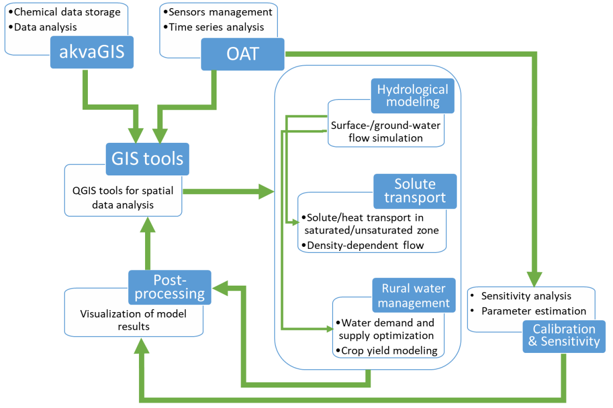
The following diagram shows how these different modules are interconnected, taking as reference a standard modeling procedure.
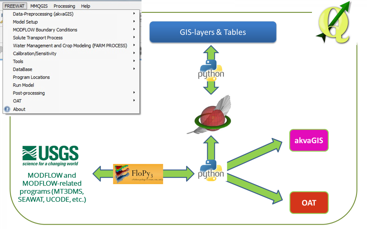
FREEWAT architecture is based on the integration of different software tools (the so called FREEWAT pillars):
- a SpatiaLite Relational Database Management System;
- dedicated tools for pre-processing of field data (akvaGIS and OAT);
- existing free and open source simulation codes (mainly belonging to the MODFLOW USGS family) for the simulation of hydrological processes
- dedicated tools for post-processing of model results.
The way of interconnecting such tools is done via Python programming language, with extensive use of the Python library FloPy.
A schematic representation of FREEWAT pillars and their interconnection is showed in the following figure.
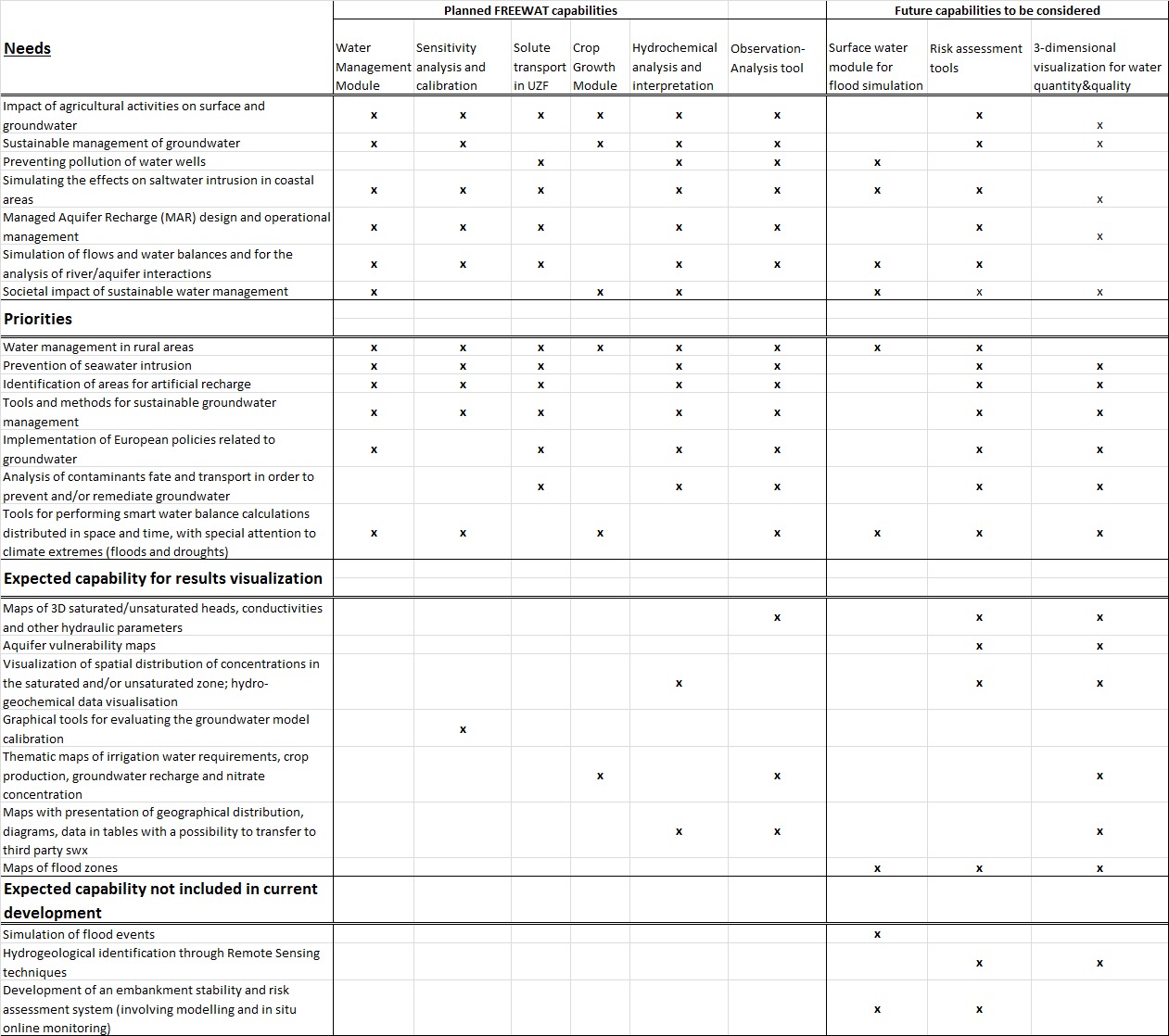
The main features of FREEWAT capabilities are illustrated in the table below, detailing the relationship between the components of the platform and the needs/priorities for ICT tools in water management, as suggested by the stakeholders interviewed during an initial survey.